November 2022
The Land Access & Recreation Association (LARA) guide, Managing Motor Vehicle Use in the Countryside, claims to give the facts about green lanes. Below we correct the many inaccurate and misleading statements and assertions made by LARA, and report on the ineffectiveness of the schemes promoted by LARA as alternatives to permanent, full-time, all recreational motor vehicle Traffic Regulation Orders (TROs)
Summary
This guide [1], published by the Land Access & Recreation Association (LARA) in June 2022, is based on a false premise. The false premise is LARA’s belief that the majority of unsealed public roads (byways open to all traffic and unsealed unclassified roads) were built in the 1860s for use by motor vehicles, and are therefore suitable/sustainable for use by motor vehicles today, if drainage and surfaces are maintained, and do not need any traffic management. This premise is incorrect. The vast majority of green roads were not built for motorised vehicles and pre-date 1860.
Unsealed roads remain as inherently unsuitable for motor vehicles today as they were when highway authorities first started to seal roads with tarmac to prevent nuisance from motor vehicles.
The photo (a horse rider and an immaculate Range Rover on a green lane) on the cover of the LARA guide is not representative of typical encounters, nor of the state of surfaces of green lanes used by recreational motor vehicles.
Maintaining unsealed ways as a management solution so that they can support recreational motor vehicles is expensive compared to maintaining unsealed ways where recreational motor vehicle use has been prohibited. Maintenance also has to be repeated regularly if motor vehicle use continues, regardless of the type of motor vehicle and the season of use.
LARA asserts that bans and closure (i.e. permanent, full-time, all recreational motor vehicles TROs) aren’t management, and are a worse outcome than collaboration with responsible recreational motor vehicle users. But highway and national park authorities which have made such permanent TROs find that they are efficient (most recreational motor vehicle use ceases) and effective (surface condition improved or stable). Monitoring by police and authority staff of TRO’d and other green lanes results in a significant reduction in illegal use.
We have identified and examined the other management solutions recommended by LARA in the scenarios in its Appendix A, e.g. voluntary restraint, flexible TROs, partial (seasonal, 4×4 only) TROs, obstructions to prevent conventional car use. All of the scenarios given by LARA have proved to be ineffective or are illegal.
There are some errors and omissions in LARA’s description of the Hierarchy of Trail Routes project and in its specifications of TRO procedures, in the guide’s appendices.
We conclude that the majority of green lanes are unsuitable for motor vehicles, contrary to LARA’s insistence that they can be made suitable by the forms of management it recommends.
Detailed comments
1. The photo on the cover of the LARA guide, of a horse rider and a Range Rover driver on a green lane, is unrepresentative of the typical encounters between recreational motor vehicle users and non-motorised users of green lanes. We provide an alternative image of such an encounter below:
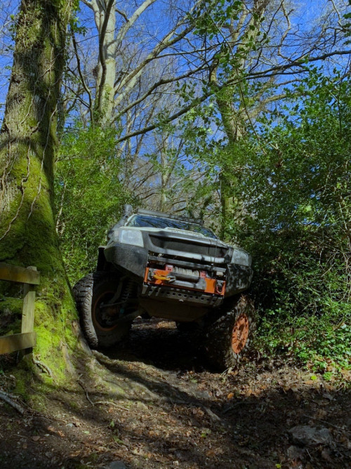
Photo from the Green Lane Association Devon Facebook page, March 2022.
Green roads/lanes were not built for motor vehicle use
2. The first sentence of LARA’s paragraph 3 asserts that the “vast majority of green roads [unsealed public roads and byways open to all traffic] were built for motorised vehicles”.
This assertion is based on a further assertion that “legislation from the 1860s required all roads to be built for motor vehicles”. If this is correct, why were green roads not sealed with tarmac in the 20th century, when the numbers of motor vehicles increased? LARA argues that drainage and surface improvements to green lanes were for motor vehicle use, not for horse-drawn vehicle use. But this argument is not supported by evidence and is contradicted by the history of road improvement, and the history of byways open to all traffic.
3. John Loudon McAdam invented the compacted stone road surfacing, now named after him, around 1820, well before the 1860s, an invention which was rapidly adopted for roads used by horse-drawn vehicles. But macadam was not durable enough for motor vehicles, the passage of which caused dust clouds and “a gradual unravelling of the road material”, problems which were initially resolved by highway authorities spraying tar on roads used by motor vehicles and subsequently by the use of tarmacadam i.e. mixing the stone with tar (now bitumen) before resurfacing, patented in 1902. [2]
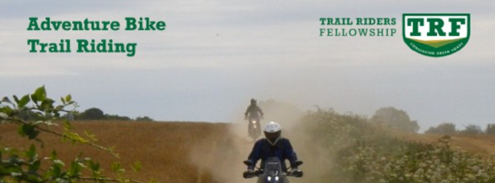
4. The reason highway authorities started sealing roads with tarmac in the early 20th century was to make them suitable for motor vehicles by preventing the dust nuisance being caused on road surfaces which had been suitable for horse-drawn vehicles. Unsealed roads remain as inherently unsuitable for motor vehicle use today as they were found to be over 100 years ago. The photo below shows two motorbikers creating a dust nuisance on a green lane, and is the current banner photo on a Trail Riders Fellowship (TRF) Facebook page:
5. The process of adding unsealed public roads to the definitive map and statement since 2006 has shown that about 10% of those added do not have public motor vehicle rights, i.e. they were historically not used by the public with motor vehicles, and certainly were not built by highway authorities for motor vehicles. This process has also shown that those unsealed public roads which do have public motor vehicular rights have these rights because they were used by the public with horse-drawn vehicles, not because they were built, or improved, after 1860, for motor vehicles.
6. John Dower, in his report of 1945 which led to the 1949 legislation establishing national parks, commented that green roads were not safe or comfortable for motorists, that “growing use by motorists was destroying the safety, comfort and pleasure of their [farmers’, riders’, cyclists’ and walkers’] use” and recommended throughout the country “segregation and selective restriction of traffic, with graduated improvement of those routes which are left open to most classes of motor traffic, and with no improvement and minimum maintenance of those routes which are reserved for walkers, cyclists and horse-drawn traffic, and closed to all motor vehicles except for the specific service of neighbouring farms.” He wrote that, in national parks, “almost all “green-lanes,” “drove-roads” and mountain and moorland cart-tracks” should be restricted to non-motorists. This would relieve the highway authorities of their “responsibility for bringing up to safe motoring standard a large mileage of routes which … it would … be very difficult and costly so to improve”. [3]
7. But this national policy for reserving green lanes for non-motorised public use did not happen, even for national parks where John Dower argued it was most needed. And no-one, in 1945, anticipated the numbers of 4x4s and trail motorbikes which use green lanes today. Instead, highway authorities made many green lanes suitable for motor vehicle use by sealing them with tarmac (e.g. to improve access for upland and heathland livestock rearing areas under the Agriculture (Improvement of Roads) Act 1955). The mileage of unsealed unclassified roads fell by at least 40% between 1987-88 and 2014/15, due to sealing with tarmac [4]. Meanwhile the total length of minor (C class and unclassified) rural roads in England has continued to increase, to 85,776 miles in 2021. [5] The vast majority of these 85,776 miles are sealed with tarmac, and are therefore available for all motorised users to enjoy the countryside. Recreational motor vehicle users say they should be able to use the very small minority (at most 4%, 3,267 miles [6]) of these minor rural roads which remain unsealed. But the improvements in the sealed road network, together with the increase in motor vehicle traffic since the 1940s, mean that horse riders, cyclists, horsedrawn carriage drivers and walkers now find it unsafe and unpleasant to use minor sealed rural roads and are even more dependent on the remaining green lanes, as a key part of the public rights of way network for safe and active recreation, than they were in the 1940s.
8. The legislation which allowed highway authorities to reclassify public rights of way recorded as roads used as public paths (RUPPs) as byways open to all traffic (BOATs) between 1968 and 2006 was first proposed by a government committee, chaired by Sir Arthur Gosling, in 1968. This committee found that many RUPPs were historically “used as drove roads or pack-horse ways or by farm carts”, that they “fell into disuse in the nineteenth century and did not become motor roads in the twentieth century” and that “the majority of them are unsuitable for motorised traffic” [7].
Disapproval of closures by vehicle users is not a barrier to prohibition
9. LARA says in paragraph 7 that it is not appropriate to prohibit motor vehicle use of green lanes because some people disapprove of it. Polls show that not all Londoners support low traffic neighbourhoods (which prohibit motorists from using residential side streets as through routes [8] ) , but this has not stopped the Department for Transport promoting their use as part of its local authority toolkit for active travel [9]. The ICM opinion poll commissioned by the Ramblers’ Association in 2004 showed overwhelming support for a ban on recreational off-roading, to protect the peace and tranquillity of the countryside.
Access for motor sports activities
10. LARA says in paragraph 8 that motor vehicle users bring a wide range of benefits including income to support local communities. It says nothing about the negative impacts which their activity has on local communities or the high cost to the public purse of having to repair, or repeatedly repair, damaged routes. LARA also says in paragraph 8 that green roads support tourist activities such as the Kielder Forest Drive and motor sport events. The Kielder Forest Drive is not a public road, but a private, toll, road. The landowner can manage traffic by limiting or withdrawing permission to use the road at any time, which is not possible on the public roads which are the subject of the LARA document. Similarly, most motor sport events take place on private land, by permission of the landowner and do not require the public motor vehicular rights presumed, or existing, on green roads.
Access for countryside activities
11. LARA says in paragraph 9 that motor vehicle access to the countryside for physical activities such as potholing, hang gliding and water sports is a benefit. But such access can be provided by permission, if a green road is found not to have public motor vehicular rights or if such rights are suspended by a traffic regulation order (TRO). LARA also says that 4-wheeled vehicles can provide people with mobility limitations with a means of access that would otherwise be denied them. What LARA does not mention is that the damage that recreational motor vehicles do to surfaces makes routes impassable for disabled people who use mobility scooters and for walkers with impaired mobility.
There is no duty to conserve recreational motor vehicle use of green lanes
12. LARA’s assertion in paragraph 15 that authorities have a duty to conserve “some aspects” of motor vehicle use, particularly in national parks, as part of the country’s cultural heritage flies in the face of what John Dower wrote in 1945 and of current efforts by government to encourage non-motorised, active travel. Also, where a long-established motor sport event is genuinely part of cultural heritage, it can be exempted from TROs excluding recreational motor vehicles, as has been done in the Peak District and Yorkshire Dales National Parks.
The majority of green lanes were built for horse-drawn carts, not motor vehicles
13. LARA says in paragraph 16 that only a small minority of green roads were ancient horse and cart tracks. This assertion is apparently based on LARA’s belief that they were built after 1860 for motor vehicles. This is incorrect. The process of adding green roads to the definitive map has shown that most were ancient (pre-1835) horse and cart tracks. The only green road which this process has shown to have been built after 1860 was found to have public footpath rights, not public motor vehicular rights, following two public inquiries [10]. Section 23 of the Highways Act 1835 inaugurated the current adoption process, by which anyone who has dedicated a new road and who wishes the road to become publicly maintainable has to make it to standards set by the highway authority, before the highway authority decides to adopt it. LARA and its members have not shown that any green lane has been adopted since 1835, as its assertion that most green lanes were built after 1860 implies.
Restrictive measures
14. In paragraph 18 LARA says that when a TRO is being considered the least restrictive measures required to resolve the problem should be applied. This proposition has already been tested in the courts and rejected [11].
Enforcement
15. LARA says in paragraph 19 that authorities should enforce against illegal and irresponsible use before considering traffic management measures. But LARA does not explain how authorities are supposed to do this enforcement, short of installing automatic number plate recognition cameras on every green lane where such behaviour takes place. Nor does LARA explain why TROs shouldn’t be used for enforcement in such circumstances. In the Yorkshire Dales National Park, TROs have been in place on ten green lanes since 2008/2010. Publicity and enforcement through joint operations by the police and rangers has been effective not only in reducing recreational motor vehicle use of the TRO’d lanes to 10% or less of pre-TRO levels, but in reducing cases of illegal use of green lanes without public motor vehicular rights, and in detecting other motor vehicle offences.
The ordinary traffic of the neighbourhood
16. LARA refers in paragraph 21 to the highway authority duty to keep publicly maintainable highways in a state of repair fit for the ordinary traffic of the neighbourhood. It fails to mention that as far as byways open to all traffic are concerned the ordinary traffic of the neighbourhood is persons on foot, cycle or horseback.
Unsuitable means unsuitable
17. LARA says in paragraphs 25 and 26 that traffic signs warning that a green road is ‘Unsuitable for Motor Vehicles’ is sufficient management to stop drivers who do not have experience of green road driving. But highway authorities use these signs for other reasons than as a filter of drivers’ experience e.g. the road may be narrow, lack passing places. If the highway is unsuitable for motor vehicles, this is a ground for a TRO, not an indication that only certain drivers should use the highway.
Codes of conduct
18. In paragraph 27 LARA mentions codes of conduct for driving on green roads. It does not say that only a minority of people driving motor vehicles on green roads/lanes are members of organisations which have codes of conduct and that there are no means of enforcing such codes. The Green Lane Association (GLASS), a member of LARA, asks its affiliate tour guides to sign up to its code of conduct. But at least one of these tour guides, Trails & Tracks 4×4 Adventures, frequently runs tours with more than four 4x4s, breaching the GLASS code of conduct.
19. In paragraphs 28 and 29 LARA cites the Lake District National Park Authority’s Green Road Code as an example of promoting responsible and sustainable use by motorists. But this code, produced in 2002, has proved ineffective in stopping illegal use (use of routes which do not have public motor vehicular rights and driving off the line of green lanes with presumed or confirmed public motor vehicular rights). Nor has it prevented an increase in motor vehicle use of green lanes classified as most vulnerable by the Hierarchy of Trail Routes classification, and green lanes classified as sustainable/’passable at all times’ in 2006 now being classified as amber (‘may not be passable in all weathers’).
Voluntary restraint
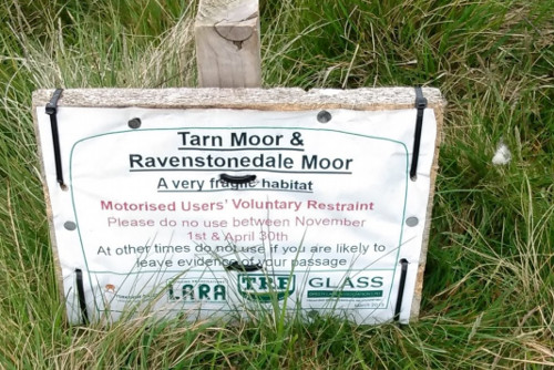
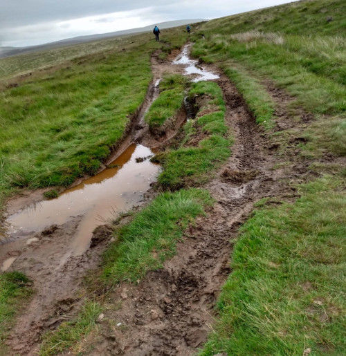
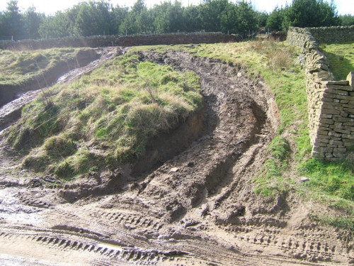
20. The voluntary restraint measures described by LARA in paragraphs 30 to 33 have not worked in the Lake District, where several lanes to which voluntary restraint applies have required repair (in some cases more than once) in the last decade, nor in the Yorkshire Dales, where motor vehicle damage to sensitive peat landscape traversed by a green lane continues despite LARA notices (see photos). This lane is part of Wainwright’s Coast to Coast walk, now designated as a National Trail.
Public Spaces Protection Orders
21. LARA says in paragraph 44 that Public Space Protection Orders (PSPOs) are cheaper to implement and enforce than TROs. What evidence does LARA have for this assertion, given that PSPOs have to be consulted on for renewal every three years?
Seasonal and other partial TROs
22. In paragraph 45 LARA promotes seasonal and 4×4 only TROs. These have not worked in Hampshire and Nottinghamshire, where the highway authority is having to make temporary TROs to repair such green lanes, in some cases more than once.
23. LARA promotes in paragraphs 48-51 flexible TROs, i.e. a TRO applied at the discretion of the authority. The only flexible TRO we know of, is operated by the Lake District National Park Authority (LDNPA) on two linked cul-de-sac green lanes. It has not been applied since 2006 because motorised users could not agree on the criteria that LDNPA should use.
TROs generally
24. Throughout its comments on TROs, LARA mentions only surface conditions and/or weather and erosion as possibly leading to the need for restrictions. There are many other reasons why a TRO may be needed, for example to remove the likelihood of danger, to conserve the amenities of the area, because of the character or suitability of the road, or for conserving or enhancing the natural beauty of the area.
Nuisance
25. In paragraphs 53 and 54 LARA says that recreational motoring can cause nuisance and that permanent TROs could be used in such cases. We agree, and say that our experience is that recreational motor vehicle use of narrow, steep and/or twisty green lanes causes significant nuisance (i.e. an injury suffered by the community or a significant section of it) to the non-motorised public wanting to use the lane. They suffer injury because they are reluctant to use their local lanes because of the risk of meeting a motor vehicle and the consequences of having to get off the route or into a hedge or up a bank, the risk of their horse bolting, and the difficulty and danger resulting from damage to the surface. By making a TRO in these circumstances, and if there is a convenient sealed alternative for motor vehicles, the authority would fulfil its duty under section 122 of the Road Traffic Regulation Act 1984 to exercise its TRO powers to secure the expeditious, convenient and safe movement of non-motorised traffic on the green lane.
‘Reasonable/proportionate’ TROs
26. In paragraph 57 LARA says its members will always support any reasonable and proportionate TRO proposals. This implies that its members do not think the full time, all motor vehicle TROs made by Oxfordshire County Council, Hertfordshire County Council, Hampshire County Council, North Yorkshire County Council, Peak District National Park Authority and Yorkshire Dales National Park Authority, all of which they opposed, sometimes in the High Court and once in the Appeal Court, are reasonable and proportionate. These TROs have not provoked an increase in illegal use, contrary to the claim made by LARA in paragraph 60. Can LARA produce any instances of their having asked an authority to impose full TROs, on the grounds that they (LARA) consider that the routes are unsuitable for recreational motor vehicles or likely to cause nuisance, no matter what other management measures have been taken?
27. In paragraph 58 LARA says that motorists may accept proportionate TROs that preserve the character of green roads. But the character of green roads with public motor vehicular rights, ie byways open to all traffic, is defined in case law as used mainly for the purposes for which footpaths and bridleways are used. LARA members’ attempts to show that green roads have the character of ordinary roads, i.e. mainly used by the public with motor vehicles, have consistently failed. Attempts to replace the long-established term ‘green lanes’ with the term ‘green roads’ are silly, tendentious schemes designed to persuade the public that green lanes are an undifferentiated part of what DEFRA calls ‘the ordinary road network’. The public, and common usage, know the difference between a tarmacadamed lane and a green lane.
LARA’s scenarios (Appendix A)
Scenario A: annual ploughing and harrowing to restore a soft turfed surface
This scenario appears to describe Sheffield City Council’s annual harrowing and re-seeding of the soft turf surface of Moscar Cross Road. This approach is acknowledged to have failed as it leaves the route impassable for non-motorised users six months of the year. Sheffield is now committed to a permanent TRO. In addition, Farming in Protected Landscapes funding has had to be used to pay for fencing to stop motor vehicles deviating from the route, damaging adjacent land and disturbing ground nesting birds.
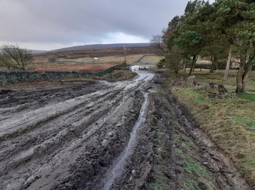
Scenario B: narrow twisting track, 4×4 damage to drystone walls and buildings – Gatescarth Pass. LARA’s solution is a permit TRO.
The details of this scenario are not accurate in describing the example given, Gatescarth Pass in the Lake District. This permit TRO was made in 2004 for the purposes of preventing damage to the byway (not to adjacent stone walls or buildings) and conserving natural beauty/better opportunities for the public to enjoy the amenities of the area. It followed a period of voluntary restraint. Despite LARA’s view that this option had not been exhausted (in its objection to the experimental TRO which led to this permanent TRO), the authority and the inquiry inspector decided that voluntary restraint had failed. The permit limits motorbike and 4×4 use to one day per month and to a specified number of vehicles. Damage is still occurring, despite this TRO. The Lake District National Park Authority is now (2022) asking for donations to maintain the byway – https://www.lakedistrict.gov.uk/visiting/things-to-do/unsealed-roads/green_road_gatescarth/gatesgarth-donation.
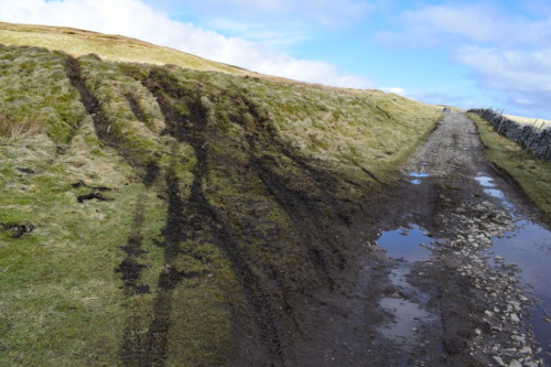
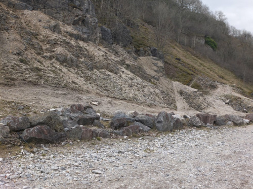
Scenario C: 4x4s leaving the definitive line of unenclosed route and damaging roadside banks or habitat
It is not only 4x4s which stray from the defined route/path/surface of unenclosed carriageways, but also motorbikes.
Scenario D: fly tipping and antisocial behaviour
How would the 4×4 TRO stop anti-social behaviour and dangerous driving by motorcyclists?
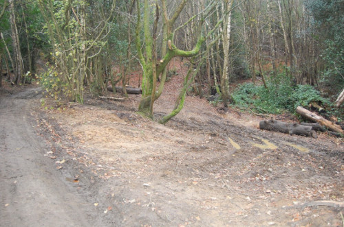
Scenario E: illegal use and damage to adjoining woodland – Wolvens Lane, Surrey
The Wolvens Lane landowners have tried to stop deviation from this route by installing tree stumps and other barriers for over 10 years. Why should they be expected to install even more expensive barriers, especially in an AONB? Surrey County Council consulted in 2021 on a TRO which would ban recreational 4x4s from Wolvens Lane. The Green Lane Association (a LARA member) has objected to this TRO.
Scenario F: Route too narrow for vehicles to pass other users
A one-way TRO might be a solution if the width is sufficient to allow 4x4s and motorcycles to pass horse riders, cyclists and walkers at the 2 metre distance specified in the Highway Code. If the lane is too narrow to allow these passing distances to be met by motorists, a full TRO should be imposed (see extract from North York Moors National Park Authority report and comment below).
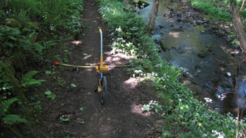
The highway authority has since (2018) made a TRO on this lane which allows motorbikes to use it, despite its narrowness. The Trail Riders Fellowship argued that one-way use by motorbikes would not be damaging.
Scenario G: disturbance of vulnerable habitats and species
Species and habitats may be vulnerable and require TRO protection throughout the year e.g. Yorkshire Sandwort on Long Lane (Clapham) in the Yorkshire Dales [12], great crested newts and heathland flora on/adjacent to Dyes Lane, Hertfordshire [13].
Scenario H: obstruction by travellers, Old Bristol Road, Shepton Mallet
A TRO is already in place at this location. At the southern end of the unsealed section of Old Bristol Road, Shepton Mallet Google Street View shows a TRO sign prohibiting cars and a gate at the northern end. Gates and Kent carriage gaps are amongst the most expensive control solutions.
Scenario I: irresponsible use, repeated surface damage and repair, Farningham, Kent
The description of this scenario suggests that the example given is the green lane near Farningham in Kent where a partial (seasonal) TRO has not been successful, because the lane still requires repairs such as annual compacting of the surface and reseeding.
Scenario J: fly tipping, Haslingden, Lancashire – LARA suggests ‘cross axle humps’,
By what legal powers has the highway authority installed cross axle humps on the BOAT near Haslingden? LARA appears to be recommending that highway authorities obstruct the highway, an action which is illegal (in the absence of a TRO) and in complete opposition to their duty to assert and protect the rights of the public to use the highway (section 130 Highways Act 1980).
Scenario K: Pisley or Holden Brook Lane, impassable for walkers and horses – LARA suggests barriers to separate motorised and non-motorised users
Where a route is a BOAT, as this lane is, walkers, cyclists and horse riders are the legal majority user and cannot lawfully be confined to only part of the way. And why should highway authorities incur the costs of erecting and maintaining barriers as well as the cost of maintaining the surface? Surrey County Council resurfaced this lane and put in stumps to stop deviation from the route in 2021. A motorbiker’s video ( https://www.youtube.com/watch?v=RVo3s78EKp8 ) shows its condition before and after the repair work. He complains the repairs mean “It’s no longer fun!”
Scenario L: Sandy Lane, widened by forestry work and irresponsible motor vehicle use, sandy wallows have become deep and treacherous, motor vehicles driven off the route mainly at night – LARA suggests voluntary restraint, a night-time PSPO or TRO to stop use after dark, volunteers to fill in wallows, landowners to stake lane to reduce it to a single carriageway and discourage deviation
This lane (Frensham Common in Surrey Hills AONB) is an SSSI (of national importance for its bird, reptile and invertebrate populations) and also common land, which mean that Natural England would have to authorise filling in of the wallows and Defra would have to authorise barriers such as staking. Reducing the width to a single carriageway would make it impossible for 4x4s to pass each other or to pass non-motorised users. We note, however, that LARA agrees that prohibiting motor vehicles from using the route by a PSPO or TRO would stop motorists driving off it.
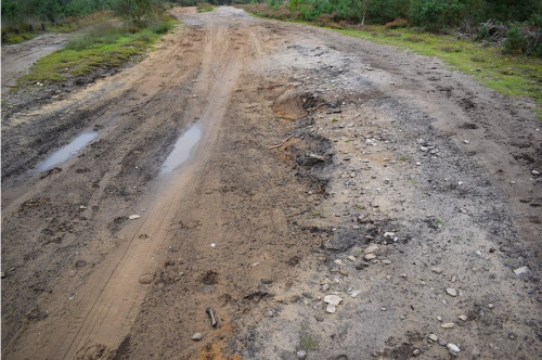
Scenario M: Breast High Road, Lake District. LARA suggests repairing/re-surfacing of this route which has deteriorated following exposure to the weather and visitor pressure, and reopening once the route is robust enough for use by motor vehicles.
The Lake District NPA is currently repairing this BOAT, only ten years after it was repaired by the highway authority. In 1895, the then highway authority described it as a road that would be seldom used, except by cattle dealers, and estimated that the cost of putting it into repair would be £329 (at 2019 prices) per kilometre. When Cumbria County Council repaired the surface and drains in 2012, the cost was £26,667 per kilometre (at 2019 prices).
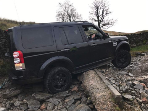
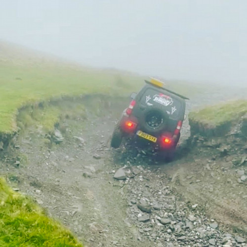
Scenario N: Surface damage caused by use when green road is waterlogged. LARA suggests a seasonal, 4×4 only, TRO.
LARA’s second example of a seasonal, targeted TRO, is one made on a cul-de-sac BOAT in 2016 by East Sussex County Council, to protect its surface over the winter, and “preserve both the character and the amenity for other users”. We wonder how the character and amenity are preserved by motorbike use throughout the year and by 4×4 use during the summer. This is a case where motorists are not using the BOAT for convenient or expeditious passage (section 122 Road Traffic Regulation Act 1984), i.e, the highway authority should have made a full TRO, to preserve the amenity of the locality. LARA’s third example is a seasonal, 4×4 only, TRO on a BOAT in Ash, Surrey. A photo of this lane, taken in summer 2012, three years after the TRO was made, shows ruts in a “muddy clay track…. passable with great difficulty by pedestrian traffic after heavy rain” ( https://www.geograph.org.uk/photo/3034027 ), i.e. the TRO was ineffective.
Scenario O: Boggy vegetation has covered an ancient stone-surfaced road, in an area designated for its nature conservation interest. LARA suggests removal of the vegetation, creation of a lateral drain, and surfacing with stone.
LARA does not provide an example, so we think this must be a hypothetical green lane. We point out that Natural England’s or Natural Resources Wales’s consent would be required for the actions suggested by LARA, because of their effects on the nature conservation interest.
Scenario P: A combination of some or all of the above scenarios over a wide area. LARA suggests a colour classification of routes according to their level of use and sustainability (e.g. the Lake District and Cumbria Hierarchy of Trail Routes), culture change, user education, voluntary maintenance and voluntary restraint.
The Hierarchy of Trails has not been effective in the Lake District; we comment above and below on how it has not prevented an increase in motor vehicle use of the least sustainable lanes, lanes which were classified as sustainable/’passable at all times’ in 2006 now being classified as amber (‘may not be passable in all weathers’), and major repair works having to be done by landowners, the national park authority and Cumbria County Council.
Scenario Q: motor vehicle drivers intimidating other users of the highway and causing damage on and off the highway. LARA suggests a PSPO, which would allow access only to members of reputable organisations.
LARA does not provide an example, but the PSPO made in 2021 by Kirklees Council for 3 linked green lanes, where damage on and off the highway has been caused by recreational motor vehicle use may qualify. It was intended that the Green Lane Association (GLASS, a LARA member) would manage permits for a limited number of 4x4s, but the PSPO has not yet been implemented, the idea of GLASS managed permits has been abandoned and Kirklees has discovered that it cannot afford to install the gates which would be necessary to manage any permit scheme [14].
Methodology for a Flexible TRO (Appendix B)
As noted above, the only flexible TRO we know of has not been used since 2006 because motorised users could not agree when it should be applied.
Hierarchy of Trail Routes (HoTR) in the Lake District (Appendix C)
This appendix concludes that the HoTR project “goes some way to providing” the need for a “properly funded and sustained maintenance regime” for green lanes. The TRF and GLASS have carried out maintenance on a few lanes in the Lake District, but major repair projects have been (Tilberthwaite)/are (Breast High Road) being funded by the landowner, the highway authority and by the National Grid’s Landscape Enhancement Initiative, all managed by LDNPA. Breast High Road was previously repaired for motor vehicle use by the highway authority in 2012, but now requires even greater investment in repair, ten years on in 2022. LARA’s conclusion that green lanes require well-funded maintenance, despite voluntary restraint, is further evidence that its initial premise, that most green lanes were built for motor vehicles, is not correct.
Procedure for making a temporary TRO (Appendix D)
LARA’s paragraph 2, when read with paragraph 4, implies that the authority must place its notice of intention to make a temporary TRO on a byway open to all traffic in the London Gazette and that the notice period is 21 days for such orders. This is a misreading of the legislation, and could mislead authorities.
Paragraph 3 also includes a misreading of the legislation, which says that the authority “shall take such steps as are necessary to secure .. the placing …of .. traffic signs …”, i.e. the use of traffic signs is not optional, as LARA suggests.
Procedure for making a permanent TRO (Appendix D)
LARA’s paragraph 12 is misleading because it does not give the full list of bodies specified in the legislation with which the authority must consult. From its summary of Regulation 6, it omits the Freight Transport Association, the Road Haulage Association, and those organisations representing persons likely to be affected by the order which the authority thinks it appropriate to consult. It also omits the requirement on the authority to consult the chief officer of police for the area (Road Traffic Regulation Act 1984, Schedule 9, paragraph 20).
Paragraph 13 is incorrect in saying that the circumstances in which an authority may hold a public inquiry do not apply to green lanes. LARA itself and its members have called for, and participated in, public inquiries into TROs on green lanes.
These sections of Appendix D omit any reference to the regulations which govern the making of TROs by national park authorities, and Defra’s guidance on these regulations. Highway authorities may find the best practice guide published by the British Parking Association, and endorsed by the Department for Transport, more useful than LARA’s Appendix D. See https://www.britishparking.co.uk/write/Documents/TIR%20Board/BPA_TRO_Best_Practice_Guide_2019.pdf
Traffic Regulation Orders (Appendix E)
LARA asserts in paragraph 3 that Parliament did not intend the first four reasons for making TROs (danger, causes damage, hinders the passage of other traffic or is unsuitable) to be used to deal with forms of common law nuisance such as anti-social motoring. Both common law and statute law are available in other areas of highway law, e.g. modification of the definitive map and obstruction, so it is not clear why LARA thinks these reasons for TROs are not applicable where recreational motor vehicle use is likely to be a danger, causes damage, hinders the passage of other traffic or is unsuitable.
LARA asserts in paragraphs 14 to 16 that TROs for ‘danger’ reasons can only be made if there is evidence of accidents or bad driving in police records. This assertion ignores evidence which the highway authority may have that the green lane is inherently unsafe, in whole or in part. For example, the Trail Riders Fellowship (TRF) challenged a TRO to avoid danger to motorised traffic made by Devon County Council on a green lane which terminates on an A road. The TRF argued that the council’s safety assessment of the junction was insufficient, but the High Court dismissed this challenge [15].
In paragraphs 23 to 26, LARA ignores the possibility that the highway authority may already have decided that motor vehicle use of the green lane is unsuitable, and placed traffic signs to this effect to deter such use.
In paragraphs 27 to 35, LARA argues that nobody is entitled to complete protection from noise and other nuisance which affects their amenity. But such protection is what national parks were established to provide, and which other green spaces should provide for the public. The effect on the amenities of the locality is, furthermore, one of the matters which authorities must have regard to when using their TRO powers (Road Traffic Regulation Act 1984 section 122).
LARA says in paragraph 42 that studies show sustainable use of green roads has a positive effect on biodiversity. It references only one study, published in 2006 [16] . This paper compared the vegetation of 20 green lanes, defined as unsealed tracks bounded by hedgerows, with the vegetation of 20 matched single hedgerows. The green lanes selected were tracks bordered on each side by a hedgerow running through farmland and used by farm vehicles, livestock, horses or people, within a 10 kilometre radius of Chester, and had a width between the hedges of more than 2 metres.
Comparison of the map of the study sites provided in the paper with Ordnance Survey mapping shows that none of the green lanes studied are legally usable as through routes by recreational motor vehicles. This, and the fact that no recreational motor vehicle use was recorded in the study, means that it tells us nothing about the effects of recreational motor vehicle use on the biodiversity of green roads. The increased plant diversity of the double hedgerow tracks compared to single hedgerows was attributed by the authors to reduced pesticide drift, greater shade (in part due to less frequent hedge cutting), increased fertility (nutrient leaching from adjacent fields, defecation from birds and other animals in the hedges and a build up of humus), not to use by vehicles.
Public Space Protection Orders (Appendix E)
LARA gives in paragraph 53 examples of traffic regulation which it says can be delivered by a PSPO. We suggest that a more general definition of the vehicular nuisance which a PSPO is designed to address can be found in the PSPO which covers anti-social behaviour and criminal activity on all highways (i.e. including green roads) in the unitary authority of Bradford. Activities prohibited by this order include activities connected to use of a motor vehicle which cause excessive noise, danger to other road users, damage or risk of damage to property, intimidation, a congregation of two or more motor vehicles which is likely to cause alarm or distress.
Notes
1 LARA, Managing Motor Vehicle Use in the Countryside https://laragb.org/blog/
2 https://en.wikipedia.org/wiki/Macadam and https://en.wikipedia.org/wiki/Tarmacadam
3 National Parks in England and Wales, report by John Dower, presented by the Minister of Town and Country Planning to Parliament by Command of His Majesty, Cmd 6628, May 1945, paragraphs 32 and 33
4 CIPFA Highways and Transportation Statistics, 1987-88, 8,896 kilometres (5,528 miles) in non-metropolitan counties in England compared to GLEAM survey figure of 3,267 miles of unsealed unclassified roads in England
5 https://www.gov.uk/government/statistical-data-sets/road-length-statistics-rdl, Table RDL0101a
6 http://www.gleam-uk.org/guidance/gleam-survey-establishes-lengths-of-green-lanes-in-england-and-wales/
7 Report of the Footpaths Committee, Ministry of Housing and Local Government, Welsh Office, HMSO, 1968, paragraphs 68 and 69
8 Street Shift: The Future of Low-Traffic Neighbourhoods, Nicolas Bosetti, Kieran Connelly, Claire Harding and Duncan Rowe, Centre for London, June 2022, pages 15-16
9 https://www.gov.uk/government/publications/active-travel-local-authority-toolkit/active-travel-local-authority- toolkit#plan-for-active-travel
10 Order decision FPS/U1050/7/62
11 e.g. Trail Riders Fellowship, Green Lane Association Ltd and Christopher Marsden v Powys County Council,[2013] EWHC 3144 (Admin), paragraph 52
12 Long Lane (Clapham to Selside), Assessment report on the use of recreational motor vehicles, Yorkshire Dales National Park Authority, January 2008, paragraphs 38 to 44.
13 Proposed permanent traffic regulation order for Knebworth BOATs 041 & 043 and Langley BOAT 021 (Dyes Lane), Hertfordshire County Council, January 2012
14 https://path-watch.com/2021/12/08/last-christmas-i-gave-you-a-public-space-protection-order-for-ramsden-road/
15 TRF v Devon County Council, [2013] EWHC 2104 (Admin)
16 Hedges and green lanes: vegetation composition and structure, MP Walker, JW Dover, TH Sparks and SA Hinsley, Biodiversity and Conservation vol. 15, pages 2595-2610

